“This was next-level in terms of the absolute deluge of water coming down so fast,” a teacher visiting New Orleans said of the heavy rain that caused the flooding.
Flash flooding from heavy rains battered New Orleans on Wednesday, and the worst might be yet to come.
Meteorologists are predicting that the Mississippi River could rise up to about 19 to 20 feet by the weekend, which is the height of the city’s levees.
The entire Gulf Coast meanwhile braced for major thunderstorms, tropical storms and possibly a hurricane over the next couple of days.
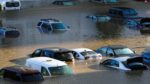
In New Orleans, nearly 10 inches of rain fell on some neighborhood of the Big Easy by noon Wednesday, as residents and visitors to the popular tourist city fled for cover or higher ground.
Terrian Jones reacts as she moves through floodwaters while carrying two children to their mother in New Orleans on July 10, 2019.Matthew Hinton / AP
The National Weather Service issued a flash flood warning at 7:41 a.m. and upgraded that to a flash flood emergency at 9:02 a.m., acknowledging that “flash flooding is already occurring with numerous streets and underpasses severely flooded.”
“Even though I grew up with Midwestern tornadoes and summer storms, this was next level in terms of the absolute deluge of water coming down so fast,” California high school teacher Ellen Austin, in town for a convention, told NBC affiliate WDSU.
“The water just came up in the streets in what felt like no time at all. And we have been cut off, with doors blocked with towels to keep water out, since this morning. It’s been a bit surreal.”
A waterspout, a kind of a tornado that forms over a body of water, was spotted over Lake Pontchartain, WDSU reported.
Louisiana Gov. John Bel Edwards declared a state of emergency in anticipation of more severe weather expected in coming days.
Edwards said heavy rains threaten to be too much for levees protecting Plaquemines Parish, which extends southeast into the Gulf of Mexico.
“Right now, we believe that any overtopping of the levees will be relatively short duration of about 12 hours, but that is still a very, very significant hazard,” Edwards said Wednesday. “We’re not sure whether the state will be opening any shelters yet.”
The governor urged his state’s residents to take be ready to move at a moment’s notice.
“No one should take this storm lightly,” he said. “As we know all too well in Louisiana, low intensity does not necessarily mean low impact.”
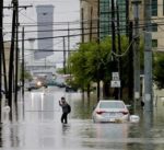
A pedestrian crosses a flooded street in New Orleans on July 10, 2019.David Grunfeld / The Advocate via AP
The surge could raise the river to 19 feet, only one foot below the height of the New Orleans levee, and the highest the river has been in New Orleans in 70 years, according to the National Weather Service. The prediction was subject to change, becoming more precise as the storm got closer to shore.
A spokesman for the Army Corps of Engineers said they’re confident that levees, which can protect up to 25 feet in some spots, 20 feet at the lowest spots, will protect Gulf Coast cities from major flooding.
Meteorologists warned of a chance that the storm could linger in the Gulf, strengthening over warm waters and landing sometime this weekend. The Gulf of Mexico is warmer than usual right now, with temperatures typical for August, which was feeding the cluster of storms.
Officials also said Wednesday would be one of the hottest days of the summer for Gulf Coast states, with temperatures expected to go above 105 degrees by the afternoon.
Texas Gov. Gregg Abbott preached preparedness to residents of eastern Texas, many who still recovering from the damage of Hurricane Harvey in 2017.
“And so begin preparing your property, begin preparing your supplies, begin preparing your lines of communication to your family members, begin preparing where exactly it is where you’ll be going to in the event you need to evacuate,” he said in Austin.
“And along those lines, establish a line of communication so you will know if any evacuation warnings will be issued by local governments.”