

Iota rapidly strengthened into a Category 5 hurricane and is expected to make landfall in Central America as a “catastrophic” storm Monday night.
Hurricane Iota has maximum sustained winds of 160 mph and is forecast to bring a life-threatening storm surge of as much as 15 to 20 feet along with rainfall of 10 to 20 inches, with isolated maximum totals of 30 inches possible, according to an advisory from the National Hurricane Center.
The storm is moving west at about 9 mph and about 100 miles east-southeast of Puerto Cabezas, Nicaragua. Iota is the first Category 5 storm of this record-breaking hurricane season and is threatening many areas of Central America that are still recovering from the devastating effects of Hurricane Eta.

A hurricane warning is in effect for Providencia, the coast of Nicaragua from the Honduras/Nicaragua border to Sandy Bay Sirpi, as well as the coast of Honduras from Punta Patuca to the Nicaragua border, according to NHC.
The storm is forecast to pass near or over Providencia Island Monday bringing hurricane conditions as it takes aim at the Nicaraguan and Honduran coasts.
Hurricane watches and tropical storm warnings are also in effect for surrounding areas.” Preparations to protect life and property should be rushed to completion,” the advisory said.
Heavy rains could bring flooding and landslide

Once the storm makes landfall it is expected to move westward and southwestward through Central America.
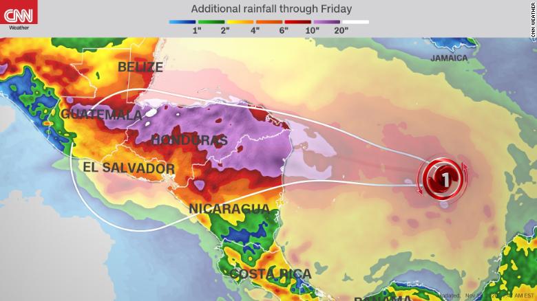
Rainfall accumulations throughout the region are expected to be high, with Honduras, northern Nicaragua, Guatemala, southern Belize seeing between eight and sixteen inches and isolated accumulations of 20 to 30 inches possible in northeast Nicaragua and northern Honduras, according to the advisory.
Costa Rica and Panama should also see about four to eight inches, with totals of 12 inches possible in some areas.
Such high rainfall amounts will “lead to significant, life-threatening flash flooding and river flooding, along with mudslides in areas of higher terrain,” the advisory warned.The predicted storm surge along the coasts of Nicaragua and Honduras will be accompanied by “large and destructive waves,” along with swells that cause “life-threatening surf and rip current conditions,” according to the NHC.
Swells will be felt from Central America to the Yucatan Peninsula, as far east as Jamaica and south Colombia.

Iota will be the second major hurricane to hit the area in as many weeks. On November 3,
Hurricane Eta made landfall as a Category 4 storm, causing landslides and flooding that displaced thousands and left scores of people dead or missing.
It is the 13th hurricane of the 2020 Atlantic hurricane season, which has left its mark as a historic season bringing 30 named storms — the most ever. More than 3.6 million people across Central America have been affected by the storm to varying degrees, the Red Cross said earlier this week.
While the full extent of the damage from Eta won’t be known for a while, the powerful storm, combined with the coronavirus pandemic, may have impacts that last for years.
The storm hovered for days over Nicaragua, Honduras and Guatemala, with heavy rains creating flooding and landslides that wiped entire communities off the map.
Dozens of people in the remote Guatemalan village of San Cristobal remain missing after a landslide swept through last week, leaving mud 50 feet deep in some places.