
Global warming is crimping the ribbon of air that controls weather systems in the Northern Hemisphere, intensifying extreme weather around the world.
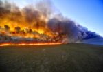
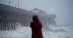
An oppressive heat wave baked Western Europe this week, setting record high temperatures in France, Germany, Poland and the Czech Republic. In India, a severe drought has choked water supplies in the city of Chennai, exposing its 9 million residents to a major shortage. And after the United States’ wettest 12-month stretch on record, towns across the Midwest and the Great Plains are reeling from devastating floods.
The reasons behind these extreme weather events are complex, but scientists believe they have a common trigger: profound recent changes to the jet stream, a ribbon of fast-moving air that flows from west to east over the Northern Hemisphere and controls weather systems.
The jet stream is powered by temperature differences between the cooler polar region to the north and warmer air masses to the south. As it circles the planet, this river of air can become rippled in places. The resulting troughs and ridges can create unusual weather patterns, amplifying cold snaps in one region and intensifying blasts of heat in another, said Jeff Masters, co-founder and director of meteorology for Weather Underground, a commercial weather service headquartered in San Francisco.
When the jet stream dips south, polar air fills in the trough, bringing heavy rains and cooler-than-usual temperatures, as has happened across much of the United States with a record-late arrival of spring and above-average precipitation. When the jet stream bulges northward, warmer air rushes into the ridge, leading to hot, dry conditions, as has happened this week in Europe.
Seasonal variations are normal, but since the early 2000s, as the planet has warmed, the jet stream has been behaving strangely. Jet stream winds, which naturally undulate, have become even more gnarled, and the big wavy patterns sometimes slow to a crawl, or even completely stall.
“The winds are actually slowing down, and it’s a very wiggly snake now,” Masters said.
A sluggish jet stream is cause for concern. When it slows or gets stuck, high- or low-pressure weather systems that correspond to the jet stream’s ridges and troughs intensify, stretching out rainy episodes, heat waves or droughts for days — or even weeks — at a time. Studies suggest that climate change is driving these new patterns, which means extreme temperatures could be more common in the future.
A pattern emerges
Unusual jet stream behavior has been recorded every three to five years since 2000 — in 2003, 2006, 2010, 2015 and 2018 — turning what scientists initially thought could be an isolated abnormality into what appears to be a pattern, Masters said.
Climate change is causing big wavy patterns to form in the jet stream, a ribbon of normally fast-moving air in the atmosphere over the Northern Hemisphere. NASA “In all of those years, we had summers with extreme conditions — both heat waves and floods that hit different parts of the globe at the same time,” he said. “We’re seeing the same pattern now. It doesn’t look like an anomaly anymore when you get these recurrences over and over.”
What is surprising to scientists now is that the wavier-than-normal jet stream has returned for a second year in a row — the first time that has been observed, said Kai Kornhuber, a climate scientist at The Earth Institute at Columbia University in New York City.
“I wouldn’t have expected this situation to return so quickly after the extreme summer last year,” Kornhuber said. “It gives me the chills to see this evolving in real time again. It’s a really worrying development.”